The geologists Dr. Kamen Bonev, Dr. Docho Dochev and Dr. Stefan Velev returned to the base with a large number of fossil samples and ore minerals after a weekly stay in unfavorable conditions in a field camp tent in a remote unexplored area. fossil. Up until their return to Bulgaria, a detailed geological map of the mentioned area will be prepared after a droning and several finishing routes.
The eight robots and three Arduino plots with sensors taken to Antarctica on a Bulgarian-Portuguese project with participants Lyudmila Filipova and Prof. Nuno Pereira were successfully assembled and released to collect data. The machines are equipped with sensors that measure temperature, pressure, humidity, solar radiation, altitude, GPS data. Upon completion of the expedition, robots will be provided to 3 Bulgarian and 2 Portuguese schools where students will learn to program and measure data as if they were in Antarctica. The project is also filmed with a 3D video, with which children will be able to transfer to the icy continent in virtual reality with special glasses.
In the international monitoring project investigating climate change, two scientists from Spain and one from Argentina with Bulgarian logistic support with snowmobiles and boats, in the region of our and the neighboring Spanish base, is equipped with precise scientific equipment with autonomous power supply which will transmit the received sensor data and during the southern winter when the two bases are uninhabited and canned
Scientific projects of the National Program for Polar Studies (NPPS), implemented in the region of the Bulgarian Base, during the astral season 2017-2018.
- For the first time, not only in Antarctica but also outside Bulgaria is a margraph station installed for year-round recording of sea level fluctuations, which is a quantitative indicator of climate change. The results obtained for global warming will be interpreted by Assoc. Prof. Borislav Aleksandrov. The station is located 3.5 meters below the surface of the South Ocean.
- Data transmission in real time from the seismic station built near the glacier Perunica begins. This will allow Chief Executive Officer Assistant Gergana Georgieva and physicist Vasil Gourev, to track the dynamics of the melting glaciers in the conditions of the changing climate.
- Filming the icy surface with a dron from physics Oleg Vassilev will present a photogrammetric model of the glaciers on Livingston Island to track their movement and determine the degree of climate warming in western Antarctica.
- Chief Assist. Ace Milka Elshishka has discovered many new representatives of nematodes in frozen soil (permafrost). Their study will allow to determine the adaptation of these invertebrates to climate change.
- Prof. Nikolay Tsankov examines the changes that occur in the skin in the raw Antarctic climate and their prophylaxis.
Creating large-scale digital topographic map for the area of Bulgarian Antarctic base
The Team of Military Geographic Service of the Ministry of Defence Colonel Peter Danchev, Deputy Head of the Military Geographic Service and Captain Georgi Mihailov from Military geographic center in Troyan and Assoc. Prof. Borislav Alexandrov and Assist. Prof. Uri Tcanovski of University of Architecture, Civil Engineering and Geodesy with the financial support of the Agency for Geodesy, Cartography and Cadastre (AGCC) are included in the composition of the 24th Bulgarian Antarctic Expedition to create a digital large-scale topographic map (strainer) in 1: 5000 for the region of the Bulgarian Antarctic base.
Topography in the extreme conditions of Antarctica will create geodetic base will make geodetic image and topographic database. It will be using the new system of symbols for large-scale topographic maps, approved late last year by the AGCC.
After making the final product will be printed deluxe copies of the map, to serve as advertising the project.
Creating an information base for study of seismicity and Earth’s structure
on Livingston Island and surroundings through complex research
in the Bulgarian Antarctic Base area
|
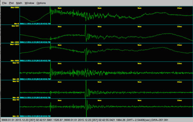
First Bulgarian broadband seismic station (LIV) was installed on 19.12.2015, within the 24th Antarctic campaign on the Livingston Island. The installation is a part of a contract DFNI I02/11/2014 "Creating an information base for study of seismicity and Earth’s structure on Livingston Island and surroundings through complex research in the Bulgarian Antarctic Base area", The contract is financed by the Science Research Fund to Bulgarian Ministry of Education and Science.
|
Your browser does not support viewing this document. Click here to download the document.
|
Preliminary geological studies of complex Byers Peninsula, Livingston Island, Antarctica
|
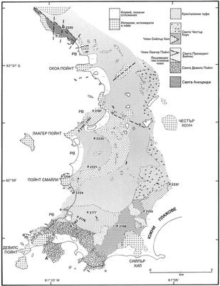
It should first be noted that so far Bulgarian paleontologists and volcanologists have not worked on the Peninsula Byers ((Pimpirev & Vangelov, 1988 have publishes data for facial decoration and the genesis of the group Byers). Some new research mostly a paleontologist stratigraphic orientation would be extremely useful to detail and clarification of age belonging to the rock sequences unfolding of the peninsula. Moreover found in short and defined as Blandfordiceras sp. aff. wallichi ammonite near BAB (Pimpirev et al., 2002 ) most likely transported precisely the area of the Peninsula Byers (Pimpirev et al., 2006). Also this author team believes that the bottom undisclosed part of the retinue Mayrs Bluff to which they relate sediments near BAB is synchronous namely Escorted Anchorage. Additional detailed stratigraphic paleontologist studies of rock sequences Peninsula Byers would confirm or reject this hypothesis, which would give a new information on rocks near BAB "St. Kliment Ohridski". It should be noted that the rocks with volcanic origin in almost every sedimentary sequence, and the fact that they occupy some relatively large areas of the peninsula (Smellie et all, 1980; Crame et al., 1993). Until now there have been no studies of Bulgarian geologists of volcanic rocks, which are in direct connection with both the sedimentary sequences and the overall evolution of the basin.
One of the main tasks of such a study is to assemble a new collection of fossil flora and fauna of selected intervals fossils rock near Byers Peninsula, the individual fossils will be accurate and layer by layer attached to the described sections. Thus it can be obtained more detailed results on Late Jurassic – Early Cretaceous age volcano-sedimentary sequences. From the above it can be concluded that up to now the only research related ammonite fauna were made by Chilean paleontologists and it nearly 40 years. Moreover ammonites are used only for direct dating of sediments without any additional data relating to biostratigraphy and taphonomy of these fossils. A good ammonite fossil sequence would enable separation of biostratigraphic zones based on ammonites and implementing a biostratigraphic scheme adopted for this age range. Thus it can be done and correlation with perceived ammonite biostratigraphic schemes that range in southern Argentina. |
Smellie et al. (1980) noted the interesting fact that the "best" ammonites are found mainly in coarse clastic rocks and rarely in alevropelite. Some new research taphonomy focus would shed light on how the preservation of fossils in these atypical for them sedimentary rocks. This will contribute to a more detailed picture of the distance and position of nourishing province clastic these rocks.
Moreover, the same team of authors noted the presence of micro fauna and macro fauna in the agglomerates and piroclastic rocks, which is rare. Smellie et al. (1980) also reported Sy stumps found in these rocks preserved in its pre-life position. Taphonomy research (which has so far not been made) of the fossil flora and fauna would help paleo environment detail of the formation of agglomerates, and the conditions in which there were found in situ plant remains. This in turn will detail information about the genesis of these rock sequences. Rare are the cases where there is a volcano-sedimentary sequences in which the volcanic litotypesi occur as tier sediments in which there is fossil fauna, which is key to the dating of certain rock intervals (in this case ammonites). It will be extremely helpful if they can be dated of volcanic litotypes using geochronological method. The presence of fossil fauna in this volcano-sedimentary sequence and by geochronological dating method makes it possible to compare data on age based on the results of the two methods for intervals which have the ability to work with both methods. |
PROJECT „SUMMITS OF TANGRA MOUNTAIN”
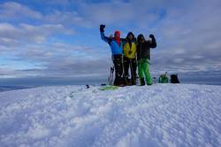
One of the goals of the 23th Antarctic expedition climbing and measuring the height of the peaks of the main ridge of the mountain Tangra situated near the Bulgarian research base in Antarctica "St. Kliment Ohridski".
Participants in the project are famous climbers Doychin Boyanov and Nikolay Petkov. They will be supported logistically by the other members of the 23th Antarctic expedition.
more ...
Participants in the project are famous climbers Doychin Boyanov and Nikolay Petkov. They will be supported logistically by the other members of the 23th Antarctic expedition.
more ...
Ecological and population-genetic research on biodiversity of bryophytes and sea mammals on the Livingston Island, Antarctica. Common and specific radiation analyses
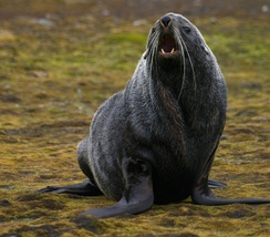
During the period 2011 – 2014, starting a new International Antarctic project, granted by Ministry of Science and Education, named “Ecological and population-genetic research on biodiversity of bryophytes and sea mammals on the Livingston Island, Antarctica. Common and specific radiation analyses.”
The scientific researches in a project aimed to reveal the potential of adaptation and ecological flexibility in model populations of bryophytes (mosses) and sea mammals (seals) on Livingston Island, under the progressive climate warming and changed radiation background, by the researches of their biodiversity, biology and ecology.
The submitted project researches have not been still conducted on Livingston Island and in order to perform the aimed tasks, new modern approaches will be applied. The project studies will contribute to the creation of considerable data base and for the increasing of the capacity of Bulgarian scientific researches in Antarctica
Permafrost and Climate Change in the Maritime Antarctic (PERMANTAR)

Permafrost is central to the carbon cycle and to the climate system, especially due to CH4 and CO2 release following thaw of organic-rich sediments. Compared with the Arctic, very little is known about the distribution, thickness, and properties of permafrost in the Antarctic. The main reason for this is the scarce network of permafrost temperature monitoring boreholes, as well as the short number of
active layer monitoring sites. There is also a general lack of section exposures and a need for observation by drilling. The main objectives of the project (March 2007 - February 2009) are:
1) Installing boreholes (deep 6 to 25 m) for permafrost temperature monitoring
(GTN-P) and sites for active layer monitoring (CALM-S);
2) Installing long-term sites for monitoring the present-day geomorphodynamics in order to evaluate the effects of climate change on landscape dynamics;
3) Identifying permafrost characteristics and spatial distribution.
4) Identifying the climate controls on permafrost temperatures and its sensitivity to climate change;
5) Studying volcano-permafrost interactions;
6) Modeling the climate variability of the Antarctic Peninsula region;
7) Evaluating the possibilities for downscaling of mesoscale atmospheric models in order to estimate ground temperatures in the South Shetlands;
8) Modeling permafrost distribution and temperature in space and time in order to assess the potential effects of climate change.
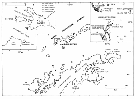
The study area is the South Shetlands, one of the Earth’s regions where warming has been more significant in the last 50 years. Field activities focus in two islands with similar climate, but contrasting geological and geomorphological settings: Livingston Island (62º39’S, 60º21’W) and Deception Island (62º43’S, 60º57’W) – see map (fig. 1). Livingston island shows high mountain relief, is 90% covered by glaciers and the bedrock in the research area (Hurd Peninsula) is a low-grade metasedimentary sequence of sandstone, shales and quartzite. The island geological setting provides an excellent site for studying and monitoring the relationships between permafrost, geomorphodynamics and climate. Deception Island is an active volcanic cone with a collapse caldera and several smaller cones. 60% of the island is occupied by glaciers. Thermal anomalies occur at several localities and the island is a very good site for studying the interactions between volcanic activity, geomorphodynamics and permafrost.
PERMANTAR – Permafrost and Climate Change in the Maritime Antarctic - contributes to the Global scientific effort to bridge the gap in the knowledge of Antarctic permafrost characteristics, sensitivity and implications for climate change.
The expected scientific results of the project focus on the influence of climate change on permafrost temperature regimes, modeling the climate variability of the Antarctic Peninsula region using mesoscale climate models (ERA-40) and spatial and temporal modeling of permafrost distribution and characteristics. A significant contribution will be the evaluation of the possibilities for using the modeling approaches to other areas of the Antarctic Peninsula where permafrost hasn’t been studied in detail. Another important contribution is the implementation of an open-access database on physical properties of the bedrock and deposits of both study areas, a service that may be at a later stage
extended to other regions of the Antarctic. These types of data archive provide invaluable ground truth for the modeling community.
PERMANTAR involves 3 Portuguese research centers rated Excellent by the Fundação para a Ciência e a Tecnologia, a Spanish research group working in the South Shetlands since 1989 and involved in 11 Antarctic campaigns and the Bulgarian Antarctic Institute contribute with logistic support of his Antarctic base and also scientists involved in the realization of the project. Argentinean researchers from the University of Buenos Aires also participated in the scientific work. An experienced Swiss company is responsible on permafrost drilling and guarantee the success in the complex drilling in the Antarctic rough environment. The project is strongly interdisciplinary in nature and there is multinational collaboration between all the research centers in all science tasks.
PERMANTAR is major contribution to the International Polar Year (IPY) core projects “TSP -Thermal State of Permafrost: an International Network of Permafrost Observatories” (IPA) and “ANTPAS - Antarctic and sub-Antarctic Permafrost, Soils and Periglacial Environments”. Antarctic logistics are provided by the Spanish Antarctic Program and by the Bulgarian Antarctic Institute (member of PERMANTAR). These countries have three research stations in the study area.
Complex geological, geochemical, geophysical and ecosystem analyzies in the region of the Bulgarian Antarctic Base “St. Kliment Ohridski”
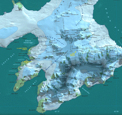
5 Years Project (2005-2010) of the Bulgarian Antarctic
Institute and the Ministry of Environment and Water
Institute and the Ministry of Environment and Water

